Tuesday 17 June, 2014, 15:21 - Satellites
Posted by Administrator
Posted by Administrator
 There is growing evidence to suggest that Google is planning to enter space by launching satellites of its own. Two seperate pieces of news point in this direction. Firstly, Google has announced plans to purchase Skybox. Skybox operates low-earth orbit satellites whose purpose is to take high resolution images, of exactly the kind that are used by Google maps. Following the recent lifting of US government restrictions on the use of images with better than 50 cm resolution, the move by Google to own its own earth imaging satellites makes complete sense.
Secondly, there is talk of Google becoming involved in the delivery of broadband via satellite through a network called WorldVu. WorldVu, if it goes ahead as described, suffers from many of the same problems that O3B will, but has a lot more to deal with due to its use of Ku-Band as opposed to O3B's use of Ka-Band.
Why is the use of Ku-Band more complex? Ku-Band is already very heavily used for satellite broadcasting, as well as for a number of satellite broadband networks (e.g. networks such as Dish in the USA). As it is proposed that the WorldVu network will be non-geostationary (e.g. the satellites will move around in the sky as seen from the Earth), the downlinks will have to be switched off when the satellites are in a position that could cause interference to existing geostationary satellite services (which will generally be when the WorldVu satellites are over the equator, and whilst a few degrees either side of it). This is made worse because any uplink that could cause interference also needs to be switched-off as well if it is pointing at the geostationary arc. The same is true of O3B, but the more dense packing of Ku-Band satellites will make the situation far more complex.
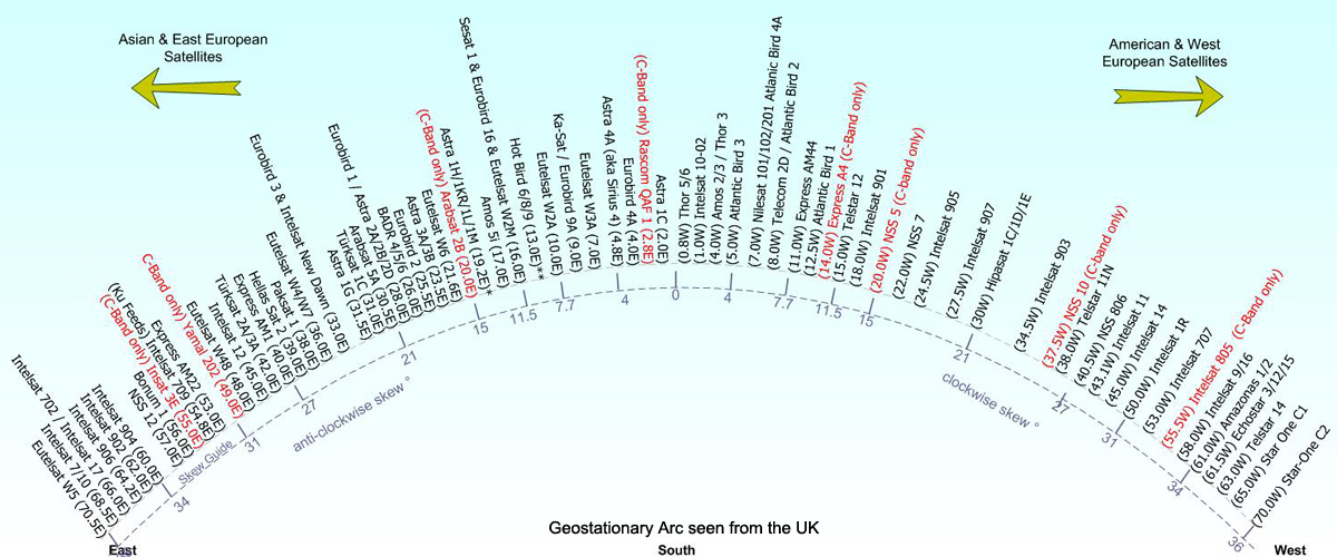
For example, there are over 60 Ku-band satellites visible in the sky in the UK. As the arc as viewed from the UK is 70 degrees from end-to-end, this means there is approximately one satellite every degree.

Source: satellites.co.uk
All of this switching on and off every time a satellite is over the equator (and, of course, when a satellite disappears beyond the horizon), and the requisite requirement to connect to a different satellite at those times to maintain a connection is both complex and also creates the environment for tremendous problems with 'dropped calls', if handover between satellites fails for any reason. Similarly, this switching will cause severe jitter (changes in timing) which in itself can cause problems for some internet applications (e.g. streaming).
Finally, and probably the weirdest issue with WorldVu, is the antennas that are planned to be deployed for user ground stations. It is suggested that Google plan to use antennas based on meta-materials. O3B have also, apparently, signed a deal to work on the development of meta-material based antennas. But at present such antennas have been proven only at Ka-Band (and then only in a developmental and not commercial form), and not at the Ku-Band proposed by Google. Even if they could be made to work at Ku-Band, there would be a loss in efficiency making transmission from Earth to space next to impossible and the fact that the antennas can only be steered around +/- 45 degrees will mean that some satellites, even when in view, will not be able to be connected to.
There is a suggestion that Google's purchase of Skybox will provide a potential platform for an early launch of the WorldVu space segment. One the one hand it makes some sense. If you are launching one satellite, why not make it multi-purpose. Though it would increase the size and weight of the satellite, and the launch cost too, having the cameras directly connected to the Internet might make sense. Then again, eyes in the sky connected to the Internet is eerily similar to the world-changing paradigm that is posited in Arthur C. Clarke's book, The Light Of Other Days. Big Brother will definitely be able to watch you, as will your neighbour, your partner, the government, and anyone else with voyeuristic tendencies who wants to. Who's zoomin (in on) you?
add comment
( 616 views )
| permalink
| 


 ( 2.9 / 1898 )


 ( 2.9 / 1898 )
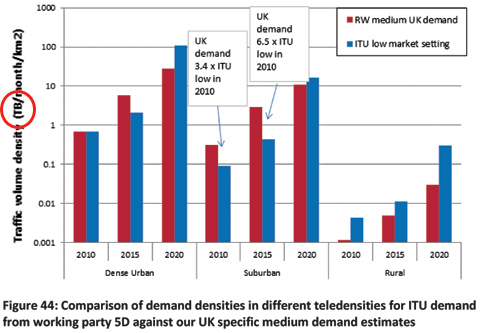
 It seems that following the ESOA submission to Ofcom concerning the apparent errors in the RealWireless study on spectrum demand for mobile data reported by Wireless Waffle on 15 Febuary, the offending report has now been re-issued (note the publication date is now 11 April 2014) with the axis on Figure 44 which shows data traffic density re-labelled from 'PB/month/km˛' (PetaBytes) to 'TB/month/km˛' (TeraBytes), thereby reducing the calculated data traffic by a factor of 1000 and now making the document internally consistent. Well done Ofcom and RealWireless, though they could have publicly admitted the apparent error, instead of quietly re-issuing the document with no fanfare. Presumably this now makes ESOA look rather silly.
But... even a 10th grade student could complete the sum that is behind the ITU data forecasts and realise that the axis should have read 'PB' all along (and therefore that the internal inconsistencies are not fixed and that the data in the ITU and RealWireless models is still hundreds of times too large). Here, for you to try, are the values - taken from the ITU's 'Speculator' model - and the maths you need to apply. The values are for 'SC12 SE2' which represents people using 'high multimedia' services in urban offices and is with the ITU model in its 'low market' market setting (it has a higher one too).
| User density: | 120,975 users per km˛ |
| Session arrival rate per user: | 3.3 arrivals per hour per user |
| Mean service bit rate: | 13.83 Mbps |
| Average session duration: | 81 seconds per session |
Now for the maths...
- First, multiply the first two numbers to get 'sessions per hour per km˛'. (120,975 × 3.3 = 399,217.5)
- Then multiply this by the average session duration to get 'seconds of traffic per hour per km˛'. (399,217.5 × 81 = 32,336,617.5)
- Then multiply by the mean bit rate to get 'Megabits of traffic per hour per km˛'. (32,336,617.5 × 13.83 = 447,215,420)
- To make the numbers more managable, divide by 8 to get from bits to bytes, then by 1,000,000 to get from Megabytes to Terabytes (447,215,420 ÷ 8,000,000 = 55.9)
The number of days in a month is relatively easy to work out, it's 30.4 on average (365.25 ÷ 12). So monthly traffic per square km would be 559 × 30.4 = 16,994 TeraBytes per month per km˛.
 This is the monthly data for just one urban traffic type in the ITU model, there are 19 others. Ignoring the others completely, Figure 44 of the RealWireless report should show monthly traffic in urban areas for the ITU model being 17,000 TeraBytes per month per square km, include the other activities that urban office workers undertake and the value should be much higher still. But it now shows as being just over 100 TB/month/square km for the ITU and less for the RealWireless prediction, 100 or more times too low. Oh dear!
 So having corrected the figure in the RealWireless report, it is now wrong. It was correct before. And it still does not tally with the total data forecast for the UK that is in the same report.
Surely there are people at Ofcom who own a calculator, have a GCSE in maths, and possess a modicum of professionalism such that they would want to check the facts before blithely allowing their suppliers to fob them off with an 'oops, we mis-labelled an axis' argument. Presumably they thought that it was ESOA who couldn't handle a calculator properly.
Now who looks silly?
Saturday 1 March, 2014, 09:03 - Satellites
Posted by Administrator
Posted by Administrator
 A consortium led by the Media Development Investment Fund (MDIF), and calling itself Outernet is planning to launch hundreds of small satellites (at 30x10x10 cm at their largest, they are about the size of a loaf of bread) to 'broadcast' the Internet. The idea is that selected portions of the internet will be broadcast using UDP-based WiFi multicasting (as well as, potentially, DVB and DRM).
Stepping aside from the political questions about who will decide which portions of the Internet will be broadcast - and which will not - there is the much bigger question of whether or not it is even possible to broadcast WiFi successfully from a satellite. There are several technical issues to overcome:
- The satellites, presumably in low earth orbit, will be several hundred kilometers above the planet, so the path loss will be significant.
- They will have to overcome interference from terrestrial WiFi networks on the same channel.
- The low earth orbit means they will not be stationary in the sky, leading to Doppler shift on the received signal.
 At a frequency of 2450 MHz, the free space path loss over 500 km (a typical height for low earth orbit satellites) is just over 154 dB. In reality, atmospheric absorption will increase the path-loss, as will clouds and rain, but let's assume it's a relatively clear, low humidity day. The satellite will therefore have to have a radiate a power of 154 - 90 = 64 dBm in order to achieve the necessary signal level on the ground. This is a power of just over 1.5 kiloWatts. At a satellite height of 150 km (about the minimum possible), path loss is around 10 dB less, meaning it would have to radiate a power of 150 Watts.
 If the transmit antenna has a gain of 10 dBi, which is very feasible, the transmitter power requirements end up being 150 Watts at a height of 500 km and 15 Watts at a height of 150 km. Note that no transmitter is 100% efficient, and the satellite would have to have receivers and control systems too, so the power requirements would be greater than that which the transmitter alone requires. If it is also assumed that the satellite is over the dark side of the Earth for some proportion of time, and has to rely on batteries, the solar power generation requirements increase, or alternatively the satellites would have to switch off at night.
Of course, high gain antennas could be used on the ground, but this would then require special equipment for the satellite to be received and would go against the concept of receiving the signal on 'smartphones and tablets'.
It is not possible to easily generate 150 Watts of power on a satellite the size of a loaf of bread. A typical satellite solar panel can generate around 300 Watts per square meter of area. The total surface area of the 'loaf' would be 0.14 square meters, meaning it could potentially generate 42 Watts of power if all faces were covered in solar panels and were in full sunlight (which is, of course, impossible as at least one face would be in shadow).
Of course, the 'loaf' could have its solar panels unfold after it is launched to make a bigger panel, so the 0.5 sq metres required to generate 150 Watts might just be possible. But this would still only provide power when the satellite was in daylight. To be powered at night it would need to generate at least double the power (one lot for the transmitter and another to charge the battery) and contain a battery capable of holding the charge. This would again be difficult on a satellite of this size.
The above transmitter power calculations assume that there is no interference on the channel. If standard WiFi channels are to be used, then depending on the location it could be expected that there would be other signals around causing interference. Assuming that the main use of the satellite will be in areas where there are no other forms of Internet connection, we could take it that there would not be WiFi interference, and so arguably we could look upon the satellite kindly and disregard this effect.
On the Doppler shift issue, at 2450 MHz, the received frequency of a low earth orbit satellite will vary by around +/- 50 kHz as it passes overhead. The IEEE standard for WiFi specifies a maximum frequency error of +/- 25 parts per million (ppm) for the 2.4 GHz band. This equates to roughly +/- 60 kHz meaning that the Doppler shift of the satellite leaves it just within acceptable frequency tolerances.
So, in conclusion:

- If the 'loaf' was at 150km height it might just be able to generate enough power to transmit a WiFi signal that is strong enough to be received on the Earth. At a height of 500 km, extending solar panels would be necessary. For use at night even larger panels, plus batteries would be needed.
- Any terrestrial interference in the band would largely obliterate the satellite signal, so it would only really be receivable in remote areas (which is, after all, it's main intention).
- Doppler shift is just within acceptable tolerances.
And you can bet that if it did work, those Governments that censor Internet access would find ways to jam the signal either terrestrially or by building their own 'loaf sat', increasing WiFi interference further. The loaf-sat-wars may be just about to get toasty...
Tuesday 26 November, 2013, 03:55 - Satellites
Posted by Administrator
Posted by Administrator
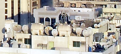
 Do a search for 'Dish Of The Day' on Google and all manner of results pop up, many cooking related, but none more dishy than sexy chef 'Pinny Rollings' here on the right. But even Pinny's dishiness pales into insignificance compared to the downright deluge of dishes on the roofs of buildings in downtown Abu Dhabi as the picture below attests (click it to see the full version and look at each building - many have dozens of dishes on their roofs).
One can but wonder whether any of these dishes actually work, or even how a situation as silly as this came about. Presumably people installed a dish to watch satellite TV and then found the service provider had moved to a different satellite. So instead of re-pointing the dish towards the new service, they installed a second dish. And then they decided they wanted services on another satellite, and instead of installing an arm capable of holding multiple LNBs, they installed a third dish. Then they found that that one of their dishes didn't work because someone else mounted a dish in front of it, so they put up yet another. And so the story goes on.

Whatever the reason, with so many dishes in close proximity, it is almost inevitable that some won't work, some don't work and some haven't worked in a long time. Surely there's a business opportunity for someone here. Firstly to go around and remove all the unused dishes (and sell them on to other people) and secondly to install CATV type systems that allow the distribution of one dish to multiple households.
There is also another question... which of these dishes is in which satellite band. There is increasing pressure for regulatory to allocate the extended C-Band (3400 - 3800 MHz) for wireless broadband services. In Europe, this spectrum is already allocated for such services through Commission Decision 2008/411/EC. If even 10% of the dishes on the roofs of Abu Dhabi are for C-Band services, then the introduction of wireless broadband services in those frequencies is a complete no-go - not without causing harmful interference, and lots of it. So in the United Arab Emirates, there is little chance of the C-Band being used for anything other than satellite reception.
But probably the most disturbing thing, is that the proliferation of dishes means that it is unlikely that Lady GaGa will perform in the country any time soon. Ms GaGa likes to stand out and what with so many other dishes around, her own dishy outfit would go largely unnoticed...


